Threats and early victories
This story begins in the late 1950s when the adverse changes affecting much of the English countryside were accelerating in this area. Coldwell is at the heart of the limestone peninsula of North Lancashire and South Westmorland. This area was bypassed by the major roads and railways, and cut off by the Kent Estuary from similar high quality limestone country around Witherslack, Whitbarrow and the Lythe Valley, which was designated as part of the Lake District National Park in 1951.
Lacking the protection afforded by the more stringent planning control that applied within the national park, the area around Coldwell became subjected to a rapid spread of housing. This spread – mostly suburban bungalows in Arnside, Storth, Slackhead and Silverdale – resulted in the destruction of many of the small family farms, fields and orchards that had previously helped to make this area special.
In addition, the whole area was subjected to increasing pressure from quarrying to satisfy a growing demand for road improvements to cope with more and faster traffic. It also faced rising numbers of countryside visitors, as well as demands for recreation and caravan park development for those visitors. And, to top it all, by 1967, there was even an engineering feasibility design and economic planning study for a Morecambe Bay Barrage.
Coldwell was severely threatened by the proposed Barrow (Arnside) Link Road. Had this gone ahead, the whole Leighton Beck valley would have been polluted and changed into a noisy urban corridor. The proposed route ran parallel to Dolly Wood Lane, followed the foot of the escarpment and passing through the Coldwell farm land, before continuing on to a high embankment over the moss land and salt marsh between Arnside and Carr Bank, to a new bridge over the Kent Estuary, before linking with the A590 and the Lindale by-pass route.
Whilst proposals to designate the area as an AONB were being fast tracked, a strong public campaign to stop the link road led to a public enquiry. Fortunately for the area, the Minister of Transport eventually refused the Link Road and Kent Estuary Bridge, whilst approving both the Lindale by-pass and the Levens Link Road. This was quite possibly the first instance of a proposed major road development in the UK being stopped on environmental grounds.
Coldwell Farm
In the interim, Coldwell Farm had been sold at public auction in 1969 to Jeffrey Bernhard and family (of Bernhards Rugby, a nationally renowned garden centre) in partnership with a local farm and dairy business from Yealand Redmayne (Tony and Sue Clarke) who had a milk round in this area. Jeffrey retained the farmhouse and 10 hectares of mixed woodland and limestone pavement that includes the beautiful springs and rock pools that drain though wet flushes in limestone grassland into the wetland moss along the Leighton Beck, forming a microcosm of the rich wild life habitats typical of this area. The Clarks’ share was the 13 hectares of better farmland to the south west.
Jeffrey Bernhard quickly recognized the unique scenic value of this landscape gem that had avoided the prevailing agricultural improvement. It had previously been a traditional stock rearing enterprise, with the whole farm open to grazing by cattle and sheep. The walls and fences were in poor condition, so at that time, the main priority was seen to be protecting the woodland and natural areas by fencing to exclude livestock.
One of the many special features was a colony of globe flowers, Trollius europaeus in the wetland by Creep-i’-th’-Call Bridge that naturally merged into a limestone pavement alongside the Leighton Beck. These flowers were recorded in the Flora of Lancashire; in the 1950s and early 1960s there was a mass of glowing golden blooms every June. Sadly, by the early 1970s they appeared to have died out.
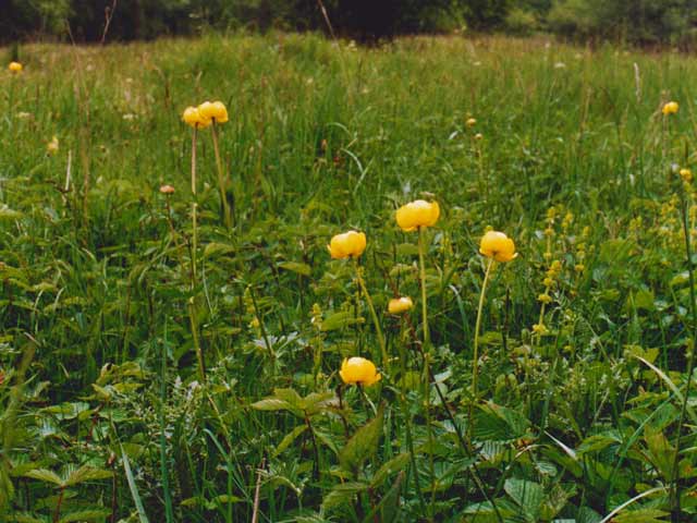
The fencing in 1979 benefitted the juniper and wild flowers, including wild daffodil, ransoms, wood anemone and bluebell. By 1990, the woodland under-storey had thickened up and all of these wild flowers, including the globe flowers were increasing.
A landscape management plan was prepared in 1992 and Coldwell Farm was one of the first farms in the AONB to have a Countryside Stewardship agreement. This helped with the restoration of walls and hedges and the reintroduction of grazing to the wood pasture and scrub clearance on the limestone grassland glades. At the same time the small area by Creep-i’-th’-Call was designated as Coldwell Farm Pasture SSSI,
“It includes over 100 plant species, four of which are nationally scarce. An area of mature semi-natural broadleaved woodland is also found within this site on exposed limestone pavement, a rare and threatened habitat in Great Britain. The grassland plant communities present are all characteristic of grazed pasture which has been traditionally managed and left unimproved over many years. Such communities are now scarce nationally and have become almost completely destroyed in Lancashire due to agricultural improvement. Shallow limestone soils covering rock outcrops support a calcareous grassland plant community dominated by blue moor-grass Sesleria albicans, a nationally scarce species, with meadow oat-grass Avenula pratensis and quaking-grass Briza media. Herbs are well represented within the sward including many characteristic species such as common rock-rose Helianthemum nummularium, wild thyme Thymus praecox, fairy flax Linum catharticum, small scabious Scabiosa columbaria and mouse-ear hawkweed Hieracium pilosella as well as three other national rarities namely limestone bedstraw Galium sterneri, spring sandwort Minuartia verna and spring cinquefoil Potentilla tabernaemontani. The calcareous grassland is representative of the Sesleria albicans — Galium sterneri community”
This description applies to much of the Arnside and Silverdale area; when replying informally to a consultation about the future management of the AONB, Jim McCarthy, Deputy Director the Nature Conservancy said, “In reality the whole area is an SSSI!”
Early Conservation Management and Development Plans
The first policies for Conservation Management and Development were prepared in February 1970 as a draft for the Countryside Commission to help make the case for the designation of the AONB. These suggested an overall landscape conservation approach for this diverse small scale scenic area, with the area subdivided into broad classes, with Class 1 being Natural Environment (restricted access) where the emphasis should be on maintaining wildlife and scientific values.
These historic draft maps, prepared nearly 50 years ago, are reproduced here for information, as it shows that some of the aspirational ideas at that time have eventually been successfully achieved whilst others superseded by a succession of more sophisticated management plans.

Countryside Stewardship
After the Countryside Stewardship agreement at Coldwell Farm, the AONB Countryside Management Service helped to promote further Countryside Stewardship and Woodland Grant schemes on most of the land around Gait Barrows. This included Yealand Hall Allotment, Challan Hall woodland, Thrang and White Moss, Thrang End and the Wood Glades, next to East Coppice (part of the old ‘enclosed’ New Park), Brackenthwaite Farm and the late David Marshall’s Leighton Beck Bridge Land.
After 1992 these management plans and Stewardship agreements with private landowners prevented further conversion to intensive farming and provided some reward for nature-friendly farm management of these closely linked areas for more than twenty years. Additionally, by restoring walls and fences they successfully helped to maintain the historic cultural scenic landscape of the AONB, whilst providing local, low input high quality meat and breeding stock, as well as providing employment for traditional agricultural and forestry craft workers.
In many people’s view, the necessity of rewarding landowners and farmers for the disadvantages suffered and the changes required in their management practices should have been an integral part of both National Park and AONB designation. It is obvious that most small scale farmers have a good understanding of the need for environmental protection and support fair stewardship, when it involves continuing or returning to the older good husbandry and traditional farming systems that have been operating in this area until the 1950s. They are hindered by having to do this alongside and as part of a mainstream farming system that has a completely different outlook – prioritising fewer and larger industrial farms with high food mileage and increasing use of mechanisation and chemicals.
In addition, climate change is making working on the land more difficult and changes in marketing and food distribution to favour large scale farming, all mean that even with a progressively improved Stewardship, it remains difficult to achieve effective restoration of some former species rich habitats, particularly wood pasture and hay meadows.
Only agreements with exceptionally dedicated and strongly committed owners are likely to achieve and sustain these longer term changes, providing public benefits, more akin to what is now called “rewilding”.

Coldwell Parrock
At Coldwell Farm, the first ten year Stewardship plan resulted in considerable improvement to the natural interest. The herb-rich grassland spread further into the adjoining meadow, and the separate fenced area of Coldwell pasture by Creep-i’-th’-Call Bridge was extended to include this area.
Ian Henderson, the Countryside Management Officer who had pioneered local interest in the management of wood pastures and conservation grazing, was provided with an opportunity to buy the horse pasture paddock at Coldwell in 2000, as the owner wished to see the scenic and wildlife interest protected and maintained. Ian arranged for the Landscape Trust as the most appropriate organisation to purchase what (at the time) was perceived as only a second tier site, to demonstrate how Countryside Stewardship could be used to maintain and restore traditional woodland pasture and limestone grassland. The Trust named it Coldwell Parrock and the first landscape design was for multi-purpose use, including nature conservation. The fact that people soon began to see increasingly obvious wildlife interest and regard it as a ‘nature reserve’ confirmed that the conservation and woodland management grazing regime was achieving its objectives.
Coldwell Meadow
Opportunity
A further opportunity came up in 2013, when the executors of David Marshall’s estate sold the 30 hectares of Leighton Beck Bridge land at auction. David loved farming and the land; he had spent the last 20 or so years of his life restoring this run-down farmland, by rebuilding derelict walls and fences, and managing it on enlightened lines as a livestock farm with sheep and cattle. Latterly, most of this land had also been in a Lower Tier Countryside Stewardship agreement.
This came shortly after Professor Sir John Lawton had given a talk at the AONB annual meeting about “Making Space for Nature”, in which he set out a clear vision of moving away from the idea of wildlife contained in isolated reserves and towards whole landscapes that are vibrant, wildlife-rich and ecologically functioning. Despite these fine words and an opportunity to extend and link Gait Barrows with other natural habitats that could be improved, neither Natural England nor the AONB were able to take a lead on this and it was left to the Landscape Trust and private individuals to take what action they could.
Purchase
After considerable debate and heart searching the trustees of the Trust decided that the most suitable land was the two meadows, the 4.00 hectares (10 acres) parcel, Lot 4 and the 3.53 hectares (9 acres) parcel, Lot 5 and that the latter was of greater natural interest, having ancient grazed woodland and limestone pavement. However the expected price was about twice what the Trust could afford, so a group of active Trust members – Ken and Ann Kitchen, Rebecca Oaks, Roger and Nancy Cartwright – pooled funds and successfully bid together with the Trust for the whole lot, which was then divided according to the amounts of money that each had put in.
After fierce competitive bidding the consortium became the proud owners of Lot 5 for £90,000. Everyone was helpful, with several members offering short term loans to meet the Landscape Trust’s share of the price.
Ownership
The Landscape Trust own the largest portion of the land — the 1.61 ha (4 acres) – 46.5%) now called Coldwell Meadow – while the other three owners have the peripheral areas, known as Boundary Lots. Ken and Ann own Boundary Copse (0.65 ha / 1.6 acres – 18.6%) which is most of the limestone pavement and woodland; Roger and Nancy own Back Lot (0.56 ha / 1.4 acres – 16.3%) at the northern end of the field; Rebecca has Boundary Field, (0.65 ha / 1.6 acres – 18.6%) an area of woodland and meadow nearest the road.
The piece that got away
The Trust had identified a sympathetic landowner who was to bid for Lot 4 but during at auction he was outbid at £109,000 for the 10 acres. This is the area of new land that the Trust has, at last, now been able to purchase this. This new land is the keystone for our new, joined-up area of land; our “Golden Horseshoe” of reserves at Coldwell that we are now seeking the funds to fully secure and consolidate.

(If you haven’t already done so, please do visit the main pages telling more about the Landscape Trust’s Coldwell Project and the “Growing Our Reserves” appeal to support it.)